February 06, 2022

Drones Reveal Patterns of Tropical Forest Canopy Disturbance
A novel dataset of five years of canopy disturbances across Barro Colorado Island, Panama, reveals abiotic drivers of spatial variation in disturbances.
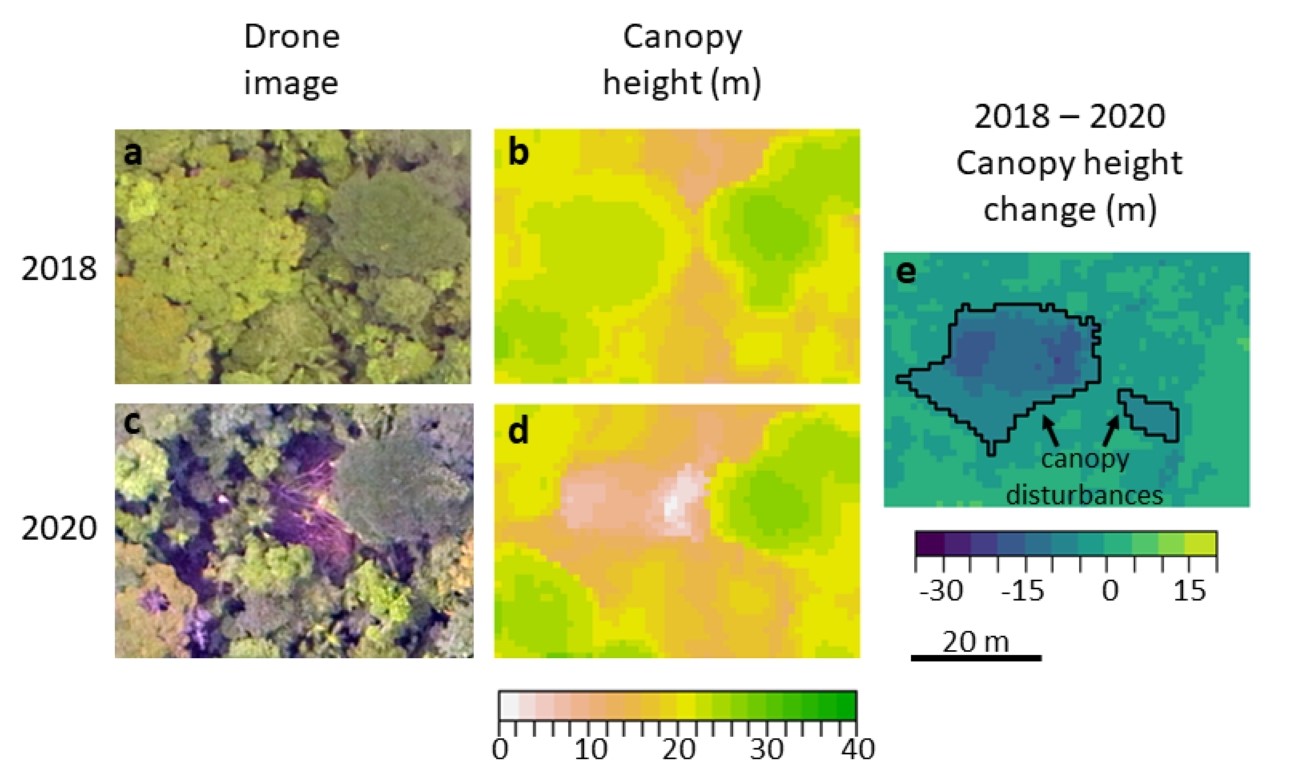
Example drone images (a, c), canopy height models (b, d), and canopy height change (e) from new canopy disturbances (e) due to treefalls between 2018 and 2020 on Barro Colorado Island, Panama.
[Reprinted with permission from Cushman, K.C., et al. “Soils and Topography Control Natural Disturbance Rates and Thereby Forest Structure in a Lowland Tropical Landscape.” Ecology Letters (Early View), (2022). [DOI: 10.1111/ele.13978] © 2022 John Wiley & Sons Ltd.]
The Science
Using five years of drone images over Barro Colorado Island, Panama, scientists identified new canopy disturbances resulting from tree mortality and damage. The resulting dataset shows that disturbance rates vary locally depending on soils, topography, and forest age. Disturbances were most strongly associated with certain soil types, and were also higher in older forests, steeper slopes, and local depressions. Additionally, disturbance rates were important for variation in forest height across the landscape.
The Impact
Tree mortality is a major control over tropical forest carbon stocks globally, but the strength of associations between abiotic drivers and tree mortality within forested landscapes is poorly understood. Previous studies have shown that mortality rates are important for variation in standing biomass regionally and globally; this study shows that the same is true on a landscape scale for mature tropical forest and identify abiotic variables that control this variation.
Summary
Repeat drone photogrammetry across 1500 ha of forest in Central Panama during 2015-2020 was used to quantify spatial variation in canopy disturbance rates and its predictors. Researchers identified 11,153 canopy disturbances greater than 25 m2 in area, including treefalls, large branchfalls, and standing dead trees, affecting 1.9% of the studied area per year. Soil type, forest age, and topography explained up to 46-67% of disturbance rate variation at spatial grains of 58-64 ha. Further, disturbance rates predicted the proportion of low canopy area across the landscape, and mean canopy height in old growth forests. Thus, abiotic factors drive variation in disturbance rates and thereby forest structure at landscape scales.
Principal Investigator
KC Cushman
Smithsonian Tropical Research Institute
CushmanK@si.edu
Program Manager
Brian Benscoter
U.S. Department of Energy, Biological and Environmental Research (SC-33)
Environmental System Science
brian.benscoter@science.doe.gov
Funding
This research was supported as part of the Next Generation Ecosystem Experiments–Tropics (NGEE–Tropics), funded by the Biological and Environmental Research (BER) Program within the U.S. Department of Energy’s (DOE) Office of Science. This research was also supported by the Smithsonian Institution Fellowship Program and the Carbon Mitigation Initiative at Princeton University. Data collection was supported by a Smithsonian Institution Competitive Grants Program for Science.
Related Links
References
Cushman, K.C., et al. "Soils and Topography Control Natural Disturbance Rates and Thereby Forest Structure in a Lowland Tropical Landscape." Ecology Letters 25 (5), 1126-1138 (2022). https://doi.org/10.1111/ele.13978.