April 22, 2020

Generating Multiresolution Meshes for Distributed Hydrological Simulations
Scientists used wavelet analysis of terrain data to generate unstructured meshes for hydrological simulations, which improved prediction accuracy.
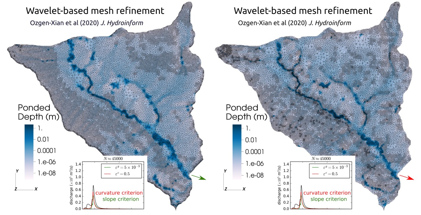
Ponding water depth computed on the multiresolution meshes generated by a slope-based refinement criterion (left); and a curvature-based refinement criterion (right).
[Reprinted from Özgen-Xian, I., et al. “Wavelet-Based Local Mesh Refinement for Rainfall-Runoff Simulations.” Journal of Hydroinformatics 22 (5),1059–77 (2020), with permission from the copyright holders, IWA Publishing.]
The Science
Multiresolution meshes are generated using a single error-threshold criterion, which are errors in the approximation of topographic slope. This technique reduces the number of free parameters that are typically needed by other approaches. In the Lower Triangle Region of the East River, Colorado, watershed, researchers used two such criteria: topographic slope and topographic curvature. Simulation results show that using curvature as refinement criteria is preferable in mountainous catchments.
The Impact
An advantage of generating multiresolution meshes is that they can often use different criteria for optimal refinement. This approach allows the generation of meshes that are able to accurately represent a broad range of processes, reducing errors, and maintaining efficient use of information.
Summary
Multiresolution mesh generation usually utilizes a number of free parameters, which are tuned by inputting field-collected data. For this study, researchers used wavelet analysis—a mathematical method for signal analysis—to reduce the number of free parameters to exactly one: the acceptable error threshold. The researchers applied the wavelet analysis on bed slope and bed curvature to generate multiresolution meshes for high-intensity overland flow simulations. They used case studies ranging from laboratory scale experiments to a subcatchment of the East River Watershed, Colorado to compare results obtained on these meshes. For the latter case, computational results indicate that meshes generated by the curvature-based criterion give a more accurate prediction of stream discharge, which implies that in mountainous watersheds, these flow processes are controlled by the curvature of the terrain. The wavelet approach is general enough to be used for a variety of different criteria to drive mesh refinement.
Principal Investigator
Ilhan Ozgen
Lawrence Berkeley National Laboratory
iozgen@lbl.gov
Program Manager
Paul Bayer
U.S. Department of Energy, Biological and Environmental Research (SC-33)
Environmental System Science
paul.bayer@science.doe.gov
Funding
This work was supported by the U.S. Department of Energy’s (DOE) Office of Science Biological and Environmental Research (BER) Program.
References
Özgen-Xian, I., et al. "Wavelet-Based Local Mesh Refinement for Rainfall-Runoff Simulations." Journal of Hydroinformatics 22 (5), 1059–77 (2020). https://doi.org/10.2166/hydro.2020.198.