August 23, 2021

New Model Rapidly Predicts Rates of Soil Drainage in Complex Tundra Landscapes
An analytical model predicts how ice-wedge polygon geometry influences the export of solute-rich waters from tundra soils to ponds and streams
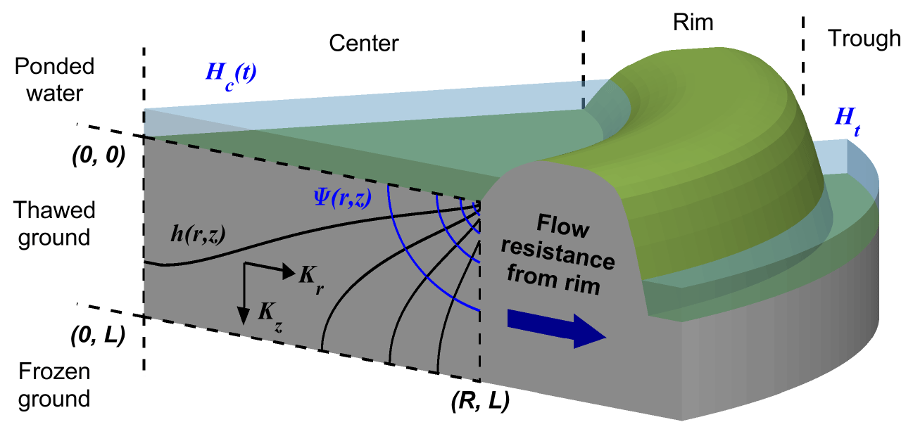
A schematic of the model, which uses fundamental hydrologic principles to simulate the physical processes of subsurface flushing of water from the central depression of an ice wedge polygon into the exterior trough.
[Reprinted under a Creative Commons Attribution 4.0 International License (CC BY 4.0) from Harp, D.R., et al. “New Insights into the Drainage of Inundated Ice-Wedge Polygons using Fundamental Hydrologic Principles.” The Cryosphere 15(8), 4005–4029 (2021). https://creativecommons.org/licenses/by/4.0/]
The Science
A new mathematical model explores how the unusual geomorphology of tundra features, known as ice-wedge polygons, influences the export of shallow groundwater into surface drainage networks. The model reveals that the fraction of the subsurface which “flushes” into surface water, potentially carrying dissolved organic carbon and other nutrients with it, is strongly impacted by geometric features that can be measured from space. This research opens the door to using ongoing remote sensing work to improve knowledge of tundra hydrologic and nutrient cycles.
The Impact
The model provides a physically-based and rapid approach to estimate the seasonal discharge of water from tundra soils to bodies of surface water, while accounting for the complex geomorphology of ice-wedge polygons. Simulating seasonal discharge mechanisms is becoming increasingly important to understanding the tundra hydrologic and nutrient cycles as climate change causes small-scale surface water bodies to expand across the Arctic. Insights from this work will be used to improve representations of Arctic surface hydrology in global-scale Earth System Models.
Summary
Ice-wedge polygons segment the soil of tundra landscapes into distinctive units resembling the cells of a honeycomb that measure up to thirty meters across. Individual polygons are often bounded by rims of soil up to a half meter high and function as miniature basins, storing surface water in the central depression. This unique geomorphology strongly impacts the partitioning of precipitation into infiltration, evaporation, and runoff. It also results in complex drainage processes, whereby the water in the central depression slowly flushes outward through the soil of the rims over the course of the summer, discharging into a network of troughs resembling a gutter system at the polygon boundaries. This flushing has the potential to mobilize large amounts of soil organic carbon and dissolved nutrients as climate change causes polygonal troughs to deepen and the discharge of water to intensify.
A new model developed by researchers at Los Alamos National Laboratory simulates this complex hydrology in three dimensions, allowing scientists to predict how quickly the ponds in the centers of polygons drain and what fraction of the subsurface is flushed by this drainage. The model reveals that drainage is strongly influenced by geometric attributes, which can be easily measured through remote sensing. Ice-wedge polygons with small diameters, for example, drain more quickly than others, and a greater fraction of the interior soil is flushed by shallow groundwater. The model also reveals that as climate change increases the depth of seasonally thawed soil in ice-wedge polygons, the fraction of the thawed portion of the subsurface which is flushed grows, increasing the potential for export of soil organic carbon and other nutrients into surface water.
Because the model uses an analytical approach to simulate groundwater flow, it runs very fast and, thus, is an ideal tool to efficiently identify the mechanisms and processes acting to move water across these unique landscapes, which are present throughout the circumpolar Arctic. Insights from the model will eventually be used to improve representation of the complex near-surface hydrology of polygonal tundra landscapes in coarse-resolution Earth System Models, such as DOE’s Energy Exascale Earth System Model (E3SM).
Principal Investigator
Charles Abolt
Los Alamos National Laboratory
cabolt@lanl.gov
Program Manager
Daniel Stover
U.S. Department of Energy, Biological and Environmental Research (SC-33)
Environmental System Science
daniel.stover@science.doe.gov
Funding
This research was supported by the Next Generation Ecosystems Experiments Arctic (NGEE-Arctic) project (DOE ERKP757), funded by the Office of Biological and Environmental Research in the U.S. Department of Energy’s Office of Science.
References
Harp, D.R., et al. "New Insights into the Drainage of Inundated Ice-Wedge Polygons using Fundamental Hydrologic Principles." The Cryosphere 15 (8), 4005–4029 (2021). https://doi.org/10.5194/tc-15-4005-2021.