May 15, 2021

Tell Us What Flux Towers See
Representativeness of eddy-covariance flux footprints for areas surrounding AmeriFlux sites.
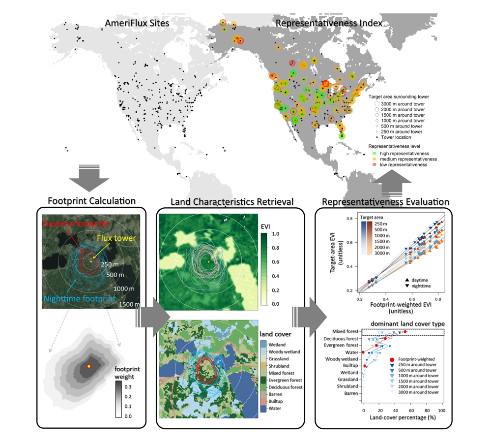
Workflow evaluating the representativeness of AmeriFlux tower “footprints” (areas that are the source for the tower’s measurements) for the surrounding areas, including footprint calculation, retrieval of land surface characteristics, evaluation of representativeness, and representativeness indices.
[Reprinted under a Creative Commons Attribution 4.0 International License (CC BY 4.0) from Chu, H., et al. “Representativeness of Eddy-Covariance flux footprints for areas surrounding AmeriFlux sites.” Agricultural and Forest Meteorology 301-302, 108350. (2021). https://creativecommons.org/licenses/by/4.0/]
The Science
Ecosystem-scale greenhouse gas and water fluxes are measured with the eddy-covariance technique at hundreds of tower stations across the Americas. These direct measurements are used in many research and management applications. A major challenge in using the flux data is their unknown and dynamic source areas, which vary with measurement heights, wind direction, and atmospheric conditions. Now scientists have developed a robust method to trace the source areas at hundreds of tower stations for the first time. They also proposed a simple index that can be used to identify sites suitable for specific applications.
The Impact
Many research and management applications use or rely on greenhouse gas and water fluxes measured at tower stations. Such applications include Earth or ecosystem models and remote-sensing products that are designated at fixed and explicit spatial extents. In contrast, flux measurements have relatively dynamic source areas. Such spatial mismatch leads to unknown uncertainties and biases. New research evaluates the potential biases resulting from the spatial mismatch at hundreds of tower stations. The study also provides general guidance for using flux data across many stations and paves the way for better integration and synergy among flux measurements, models, and remote-sensing.
Summary
Large datasets of greenhouse gas and water fluxes measured with the eddy-covariance technique (e.g., AmeriFlux and FLUXNET) are widely used to benchmark models and remote-sensing products. This research addresses one major challenge facing model-data integration: To what spatial extent do flux measurements taken at individual eddy-covariance sites reflect model- or satellite-based grid cells? The study evaluates flux footprints—the temporally dynamic source areas contributing to fluxes—and the representativeness of these footprints for target areas often used in synthesis and modeling studies. Scientists examine the land-cover composition and vegetation characteristics across AmeriFlux sites and evaluate potential biases due to the footprint-to-target-area mismatch. Monthly footprints vary across sites and through time ranging four orders of magnitude from 1,000 to 10,000,000 m2. Few eddy-covariance sites are located in a truly homogeneous landscape. Thus, the common model-data integration approaches that adopt a fixed-extent target area across sites introduce biases on the order of 4%–20% for vegetation characteristics and 6%–20% for the dominant land cover percentage. The findings highlight the need for flux datasets to be used with footprint awareness, especially in research and applications that benchmark against models and data products with explicit spatial information.
Principal Investigator
Housen Chu
Lawrence Berkeley National Laboratory
hchu@lbl.gov
Program Manager
Jennifer Arrigo
U.S. Department of Energy, Biological and Environmental Research (SC-33)
Environmental System Science
jennifer.arrigo@science.doe.gov
Funding
This research was supported in part by funding provided to the AmeriFlux Management Project by the U.S. Department of Energy’s Office of Science under Contract No. DE-AC0205CH11231. Thanks to the AmeriFlux site teams for sharing their data and metadata with the network.
References
Chu, H., et al. "Representativeness of Eddy-Covariance Flux Footprints for Areas Surrounding AmeriFlux Sites." Agricultural and Forest Meteorology 301-302, 108350 (2021). https://doi.org/10.1016/j.agrformet.2021.108350.