October 01, 2020

Improving Predictions of Water Availability and Quality in Watersheds
New modeling tool accurately simulates water flow in complex and post-disturbance soils.
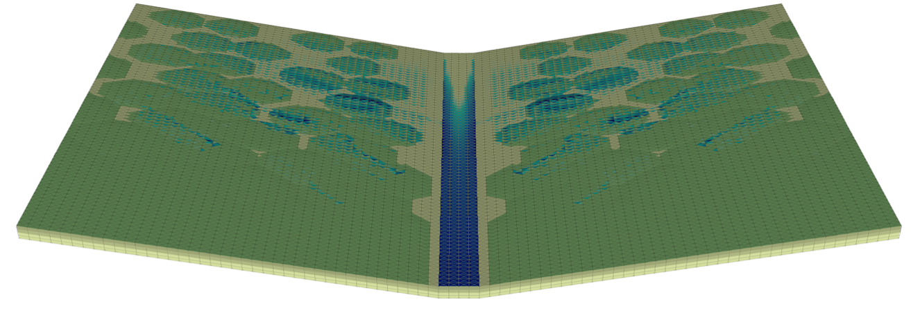
An example simulation showing patterned ground with variable land cover (in greens) and surface water (in blues) during a rainstorm. The green, organic-rich soil is able to store more water due to higher porosity, changing the hydrologic response of the entire catchment.
[Ethan Coon, Oak Ridge National Laboratory]
The Science
Understanding how the water cycle is responding to drought, fire, warming, and increased human demand requires computer models that can represent complex environments. A multi-institutional team of scientists derived a new mathematical formulation that greatly improves the ability of models to predict runoff, even in cases where the soil structure is complicated. In particular, cases like patterned land cover, variable soil layers, and other complex soil conditions make accurate predictions hard, but this new method works well for even the most complex landscapes.
The Impact
Most natural landscapes are complex, and that complexity is both hard to measure and hard to simulate. A mathematical formulation that appropriately captures that complexity will lead to advances in predicting how the water cycle will change over time in a given watershed. These predictions can then be used to inform local stakeholders and help them make decisions about the use of water from a watershed of interest.
Summary
Watershed function, including a watershed’s ability to provide clean, available water, is often significantly altered by the local complexity of the land surface and underlying soils. Understanding that complexity requires models that can first represent the complexity and next solve for real-world scenarios of water conditions accurately and efficiently. A multi-institutional team of scientists developed a new mathematical formulation that appropriately captures that complexity and implemented it in DOE’s Advanced Terrestrial Simulator (ATS) code. This new feature of ATS allows scientists to accurately predict how water flows both below and on the surface of landscapes, including how it partitions between groundwater and surface runoff to streams. This formulation was derived and tested against a series of benchmark problems, and shown to be more accurate than previously used methods on complex landscapes. This and other advances in ATS now allow scientists to accurately simulate the water cycle in complex landscapes, including cases of post-fire storms on patchy burn scars and variable depth-to-bedrock over a given spatial area. This new modeling capability provides a significant advance toward better predictions of water availability and quality in a watershed.
Principal Investigator
Ethan Coon
Oak Ridge National Laboratory
[email protected]
Program Manager
Paul Bayer
U.S. Department of Energy, Biological and Environmental Research (SC-33)
Environmental System Science
[email protected]
Funding
This work and its large team of investigators were continuously supported over a long period by several DOE Office of Science Biological and Environmental Research projects, including the Next Generation Ecosystem Experiment – Arctic project, the Interoperable Design of Extreme-scale Application Software (IDEAS) project, and Laboratory Directed Research and Development funds from both Oak Ridge National Laboratory and Los Alamos National Laboratory.
Related Links
References
Coon, E. T., D. Moulton, E. Kikinzon, and M. Berndt, et al.. "Coupling surface flow and subsurface flow in complex soil structures using mimetic finite differences." Advances in Water Resources 144 103701 (2020). https://doi.org/10.1016/j.advwatres.2020.103701.