Coastal Observations, Mechanisms, and Predictions Across Systems and Scales—Field, Measurements, and Experiments (COMPASS-FME)
Improving fundamental scientific understanding, model representation, and predictive capacity of coastal systems
Project website | Overview brochure PDF
Principal investigator: Vanessa Bailey
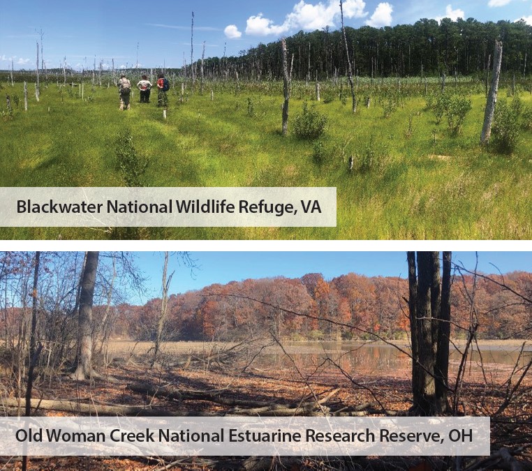
Studying sites in two distinct regions, the Chesapeake Bay (top) and the Western Lake Erie Basin (bottom), provides COMPASS-FME with an interesting contrast of saltwater and freshwater coasts that allows researchers to differentiate the impacts of inundation and coastal water chemistries in nationally important coastal systems.
Coastal regions—zones where the land margin meets large, open water bodies—are home to high proportions of global population, trade, infrastructure, and biological productivity. The importance of these critical zones to understanding the integrated Earth system continues to grow, especially as disturbances increasingly threaten coastal energy, economic, ecosystem, and national security assets. Coastal systems are dynamic and, in many cases, are rapidly changing due to a wide range of natural and anthropogenic influences, such as sea level rise, hydrologic intensification, land-use and land-cover change, and urbanization.
As critical as coastal zones are to the planet, much of the science needed to understand and predict their behavior—from molecular processes to global scales—is limited by insufficient mechanistic data and inadequate quantitative and predictive tools. Further, processes and interactions in coastal regions function at different temporal and spatial scales, often across compressed spatial zones, making them difficult to represent in Earth system models (ESMs).
New national priorities for enhancing Earth system predictability reinforce the importance of taking on these challenges. COMPASS-FME aims to improve the reliability and predictive power of ESMs by combining advanced computation with focused observational data to represent the complexity of coastal systems more accurately. Supported by the U.S. Department of Energy’s (DOE) Biological and Environmental Research (BER) program, this project investigates how the frequency and duration of flood events affect terrestrial-aquatic interface (TAI) ecosystems and how the consequences of these events propagate through water, sediments, soils, microbes, and plants to cause ecosystem-state changes in both saltwater and freshwater TAIs.
Key Science Questions
The COMPASS-FME project seeks to advance a scalable, predictive understanding of fundamental biogeochemical processes, ecological structure, and ecosystem dynamics that distinguish coastal TAIs from purely terrestrial or aquatic systems.
Research blends measurements and models to answer overarching long-term science questions:
- What are the fundamental ecological, biogeochemical, and hydrological control points that govern the structure, function, and evolution of coastal TAIs?
- How do these control points interact across multiple spatial and temporal scales, and what mechanisms and interactions are most important to improving predictive models that can cross scales?
Reaction and Transport Control Points
Predicting how coastal systems respond to disturbances and long-term changes requires new mechanistic studies of interacting processes, system connections that operate through soil-microbe-vegetation subsystems, and disturbance impacts. COMPASS-FME research is advancing the mechanistic understanding and representation of coastal ecosystem structure and function in response to hydrologic disturbances in the Chesapeake Bay and Western Lake Erie Basin. The project focuses on disturbance events arising from hydrologic cycle intensification and characterized by more variable and intense precipitation patterns, flooding events, storm surges, and seiches. Measurements, experiments, and models are directly linked to improve predictive understanding of these important systems.
The project will determine how flood frequency, duration, and depth affect ecosystem functions and interactions among soil properties, plant traits, and nutrient and redox chemistry that emerge as control points for carbon (C) oxidation and other coupled processes.
To accomplish this, the team integrates the following to develop a conceptual understanding of control points that govern ecosystem processes and responses to varied hydrologic drivers:
- Synoptic sites in both regions characterize how ecosystem structure and function, including soil, groundwater, and vegetation, vary with changing water levels. Temporally resolved measurements characterize water-sediment-soil-microbe-vegetation systems across the TAI from shoreline to upland forest at 7 intensively monitored field sites.
- Lab incubations of soil and sediment cores, batch experiments, and soil transplant experiments in the field assess the effects of inundation (with and without salinization) on biogeochemical cycles at synoptic sites.
- New and improved model development for complex coastal systems emphasizes biotic and abiotic processes that are dominant at scales ranging from molecular reactions to site-scale transects.
Scaling Predictive Understanding
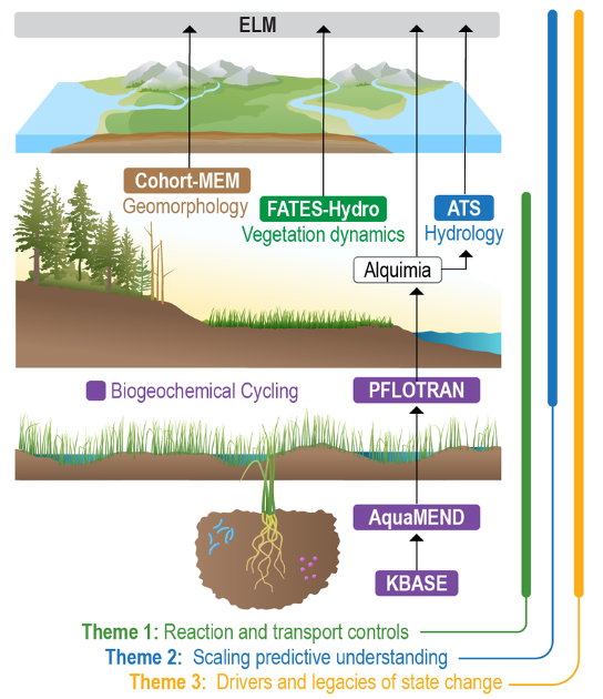
Multiscale Models. COMPASS-FME uses a suite of multiscale models to investigate relationships between water, plants, soils, sediments, and microbes.
Projecting the evolution of interconnected coastal systems requires an integrated modeling approach that leverages improved mechanistic understanding and extends it across scales to simulate future changes along the land-river-coast and atmosphere-surface-subsurface continuums while accounting for key natural processes and human influences. COMPASS-FME builds on previous work by DOE national laboratories and the university research community to establish process-rich, integrated modeling capabilities that can be enhanced, coupled, and applied to address important science questions.
This theme integrates data, models, and networked science to identify how flooding history determines the dominant control points for C oxidation and other coupled processes along the open-water–wetland–upland gradient. The team captures these spatial control points and processes in models. Activities integrate the knowledge gained from field observations and experiments into a predictive framework.
- Synthesizing research and data beyond COMPASS-FME derives new mechanistic controls on ecosystem function that improve models and inform experimental and observational efforts.
- Exploration of Coastal Hydro-biogeochemistry Across a Network of Gradients and Experiments (EXCHANGE) brings together the external research community to address COMPASS-FME and community research priorities to provide regional context for synoptic observations and spatial patterns for grid-cell scale modeling.
- Scaling focuses on developing and improving models for complex coastal systems to predict shifts from C oxidation to carbon dioxide and methane production with redox fluctuations at site to E3SM Land Model grid-cell scales.
Drivers and Legacies of State Change
The team is conducting field-scale water-level manipulations to examine the impacts of repeated flooding via lake-level change, storm surge, and freshwater flooding. Activities include the Terrestrial Ecosystem Manipulation to Probe the Effects of Storm Treatments (TEMPEST) and the Lake Erie Manipulation. These experiments will identify transferable and nontransferable processes that regulate ecosystem-state change and dominate biogeochemical fluxes and transformations in coastal ecosystems across sites and regions using large-scale field manipulations of water levels.
Collaboration
Led by Pacific Northwest National Laboratory, COMPASS-FME is a collaborative effort that includes scientists at Argonne National Laboratory, Lawrence Berkeley National Laboratory, Los Alamos National Laboratory, Oak Ridge National Laboratory, the University of Toledo, and the Smithsonian Environmental Research Center. COMPASS-FME builds on current BER modeling investments in the mid-Atlantic by expanding ongoing research in the Chesapeake Bay and Great Lakes and providing essential biogeochemical and ecological data to support long-term model improvement for these regions.
A companion program to COMPASS-FME, COMPASS-Great Lakes Modeling, conducts research to improve regional ESMs to understand climate feedbacks in the Great Lakes region.
All COMPASS-FME data are available at data.ess-dive.lbl.gov/portals/compass. These data include automated data collected from in situ sensors located in soil, waters, and plants; large campaign-based fieldwork collections; community science efforts ([email protected]); synthesis and meta-analysis datasets compiled from published and unpublished studies; and discrete datasets generated from chemical, biochemical, and molecular characterizations of soil, water, and microbial or plant samples. BER provides funding to leverage the COMPASS investment through regular Funding Opportunity Announcements posted at grants.gov.