River Corridor Hydro-biogeochemistry from Molecular to Multi-Basin Scales Science Focus Area
Transforming understanding of spatial and temporal dynamics in river corridor hydro-biogeochemical functions from molecular reactions to watershed and multi-basin scales
Project website | Overview brochure PDF
Principal investigators: James Stegen, Xingyuan Chen, and Allison Myers-Pigg
Annual reports: 2023 | 2022 | 2021 | 2019 | 2018 | 2016 | 2015 (Note: Reports are not issued during review years.)

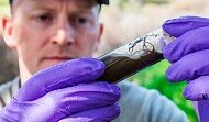
River Corridor Hydro-biogeochemistry from Molecular to Multi-Basin Scales Science Focus Area (RC-SFA). The RC-SFA studies wildfire and drying of streams as two interacting perturbations that are shifting in frequency, duration, and severity and have highly uncertain impacts on watershed hydro-biogeochemistry (HBGC). [Courtesy Pacific Northwest National Laboratory]
Key Scientific Questions
RC-SFA researchers are developing mechanistic understanding of coupled hydrologic and biogeochemical processes across river corridors spanning a wide range of environmental features. The SFA aims to generate transferable and predictive understanding from molecular to multi-basin scales. Key questions include:
- How do wildfires, vegetation, and other environmental features jointly influence hydrologic connectivity?
- How do wildfire and variable inundation interactively influence sediment-associated respiration?
- How do perturbations impact temporal variation in the spatial scaling of sediment-associated respiration?
Translating Process Understanding Across Scales
RC-SFA research employs a hypothesis-centered approach for integrating modeling and experimentation (ModEx) at multiple spatial scales. In this approach, conceptual and mechanistic understanding guide model development. Model predictions guide data generation, and interpretation of generated data further guides model development.
The RC-SFA combines ModEx iteration with intensive place-based research and widely distributed efforts to generate deep mechanistic understanding that is transferable across environmentally diverse watersheds. Measurements and models are integrated from molecular scales emphasizing organic matter thermodynamics to whole watershed scales emphasizing hydrologic connectivity.
Due to its varied environmental features, the Yakima River Basin in Washington serves as the RC-SFA’s single-basin testbed for evaluating hypotheses that can be further tested across multiple basins. To evaluate transferability across the contiguous United States, RC-SFA works with the Worldwide Hydrobiogeochemistry Observation Network for Dynamic River Systems (WHONDRS) via a participatory science approach.
Throughout all scales and phases of research efforts, the RC-SFA places significant emphasis on team science built on the foundation of a safe environment for all. This emphasis is essential for delivering project outcomes that are simultaneously transferable across environments and mutually beneficial among interested parties. To foster this environment, the RC-SFA uses integrated, coordinated, open, and networked (ICON) science principles to guide the design and implementation of research efforts. Intentional alignment with these principles ensures project deliverables are integrated across disciplines and scales, coordinated with consistent methods, open throughout the research lifecycle, and networked across interested parties to understand and meet needs of those beyond the core team.
Watershed Perturbations

RC-SFA Sites Within the Yakima River Basin. North Fork Rattlesnake Creek during spring snowmelt, showing the impact of wildfires on water turbidity (left). Aerial view of Umtanum Creek, a nonperennial stream affected by the Evans Canyon fire in 2020 (right). [Courtesy Pacific Northwest National Laboratory]
HBGC processes modulate water quality, nutrient dynamics, and energy and material fluxes. Perturbations rarely act alone and often compound each other, making it vital to understand their interactive effects on HBGC processes and the cascading impacts on regional and national water challenges.
Given the global relevance and shifting impacts of these perturbations, researchers need clarity on how they jointly impact watershed HBGC. Otherwise, the risk of uncertain predictions increases for future land surface water and organic matter dynamics. The RC-SFA will protect against this risk through a novel focus on interactions between wildfire and variable inundation across environmentally divergent basins of the contiguous United States.
Open Watershed Science by Design
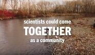
Fully understanding the functioning and dynamics of large and complex watersheds on a continental scale is intractable for individual researchers or even a single research team. Through intentional use of ICON science principles, the RC-SFA enables and partners with a research community that can more effectively solve large scientific challenges through participatory science modalities. For example, WHONDRS is stewarded and coordinated by RC-SFA scientists. WHONDRS is a global consortium of researchers to understand coupled hydrologic, biogeochemical, and microbial function within river corridors, with an emphasis on increasing accessibility of resources and knowledge throughout the research life cycle.
As of November 2024, 27 WHONDRS community data packages have been openly published in DOE’s Environmental System Science Data Infrastructure for a Virtual Ecosystem (ESS-DIVE) data repository. A portion of these is part of the RC-SFA’s 58 open datasets.
Videos


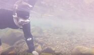
Mapping Underwater Chemical Activities
Researchers at PNNL re-engineered a technique known as electrical resistivity tomography to study waterway interactions. (2020)

WHONDRS Research Consortium
Overview of the aims and goals of the WHONDRS research consortium. (2019)
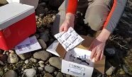
WHONDRS Surface Water Sampling Protocol
Demonstrates protocol for a global-scale community-enabled study of surface water metabolomics led by WHONDRS (2019)
WHONDRS Diel Cycling Study Protocol
Demonstrates protocol for 48-hour Diel Cycling Study for WHONDRS (2018)
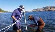
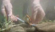
New Hydrobiogeochemistry Sensor in River Corridors
New sensor technology for estimating the mass flux of water through subsurface sediments in dynamic systems. (2018)
Multidisciplinary Instrumentation and Modeling
Details of a Columbia River experiment to help predict hydrobiogeochemical function under future environmental conditions. (2017)
Real-time 4D Subsurface Imaging
2016 R&D 100 Award-winning imaging technology that enables researchers—for the first time—to take four-dimensional views of the subsurface. (2016)