January 31, 2022

Scientists Advance Methods to Better Predict Watershed Responses to Climate Change
Watershed zonation approach allows tractable quantification of above- and below-ground watershed heterogeneity and associated response to disturbance.
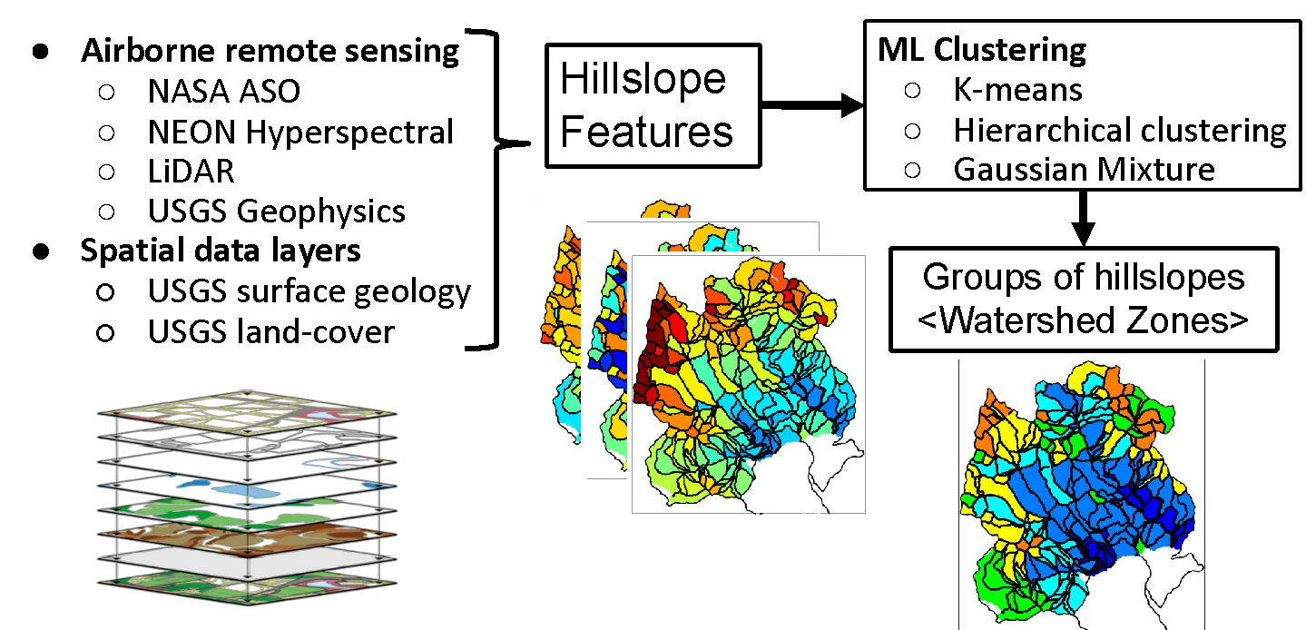
Diagram of the watershed zonation workflow in which multiple unsupervised clustering methods were applied to bedrock-to-canopy spatial data layers for grouping hillslopes with similar above/below-ground environmental features.
[Courtesy Lawrence Berkeley National Laboratory.]
The Science
More than half of Earth’s freshwater comes from mountainous watersheds. Watersheds are “systems of systems,” meaning there are many interacting compartments—such as bedrock, soil, and snow plants—that affect their functioning. Predicting watershed behavior is challenging because there are different environmental processes and characteristics—both at different scales and levels, from bedrock to the atmosphere—that affect watershed function and water quality. To understand how watersheds may respond to droughts as climate changes, researchers used data from the Colorado East River Watershed to develop a watershed zonation approach—a method that uses machine learning to characterize entire watersheds by grouping zones of similar functioning and characteristics, like watershed “zip codes.” The team grouped hillslopes since these features are a functional unit in hydrology. Hillslopes capture waterflow and a range of environmental characteristics like elevation, topography, and vegetation. This method combines data of multiple types and scales of state-of-the-art airborne remote sensing data layers to identify zones with similar bedrock-to-canopy features. The method also shows how these areas respond to disturbances in different ways to advance holistic and large-scale predictions of watershed response to change.
The Impact
Watershed function can significantly impact energy production, agriculture, and water quality and availability. Now that the frequency and intensity of environmental disturbances, such as drought, wildfires, and floods are in what many have called a “new normal” state, scientists can no longer depend on historical trends to project future watershed behavior, but instead need to develop new approaches for studying watershed response to environmental changes. However, predicting watershed behavior is challenging because watersheds are extremely heterogeneous, including the complex interactions taking place across different Earth compartments from tree canopy to the deep subsurface as well as from one hillslope in a watershed to another. Using machine learning, researchers organized the watershed research site into zones based on similar environmental features and were able to show how different zones process/export nutrients and respond to droughts. By using multiscale spatial data layers to capture different characteristics throughout a watershed, this approach allows for more accurate large-scale predictions of watershed responses to climate change. Understanding these responses is critical for managing and protecting critical freshwater resources as water demand continues to increase.
Summary
This paper developed a watershed zonation approach—a method that uses unsupervised machine learning—to characterize the heterogeneous bedrock-to-canopy compartments and their impacts of watershed function by identifying the zones of similar functioning and characteristics. The method was demonstrated using the multiple remote sensing and existing spatial data layers collected at the East River Watershed (Crested Butte, Colo.), including snow-on/off LiDAR, airborne electromagnetic surveys, landcover classes, and geology maps. A team of researchers considered a hillslope to be a fundamental unit for watershed hydrology and element cycling, funneling water and elements from the ridge to the river, as well as representing aspect controls on critical zones. For clustering, researchers compared k-means, hierarchical tree, and Gaussian mixture methods, and confirmed that the zones are consistent across different methods. In addition, this study provided a significant understanding of the multi-compartment watershed heterogeneity: (1) it is possible to define the scale of hillslopes at which the hillslope-averaged metrics can capture the majority of the overall variability in key properties [such as elevation, net potential annual radiation, and peak snow-water equivalent (SWE)], (2) elevation and aspect are independent controls on plant and snow signatures, and (3) near-surface bedrock electrical resistivity (top 20 m) and geological structures are significantly correlated with surface topography and plan species distribution.
Principal Investigator
Haruko Wainwright
Lawrence Berkeley National Laboratory
[email protected]
Program Manager
Jennifer Arrigo
U.S. Department of Energy, Biological and Environmental Research (SC-33)
Environmental System Science
[email protected]
Funding
This material is based upon work supported as part of the Watershed Function Science Focus Area funded by the Biological and Environmental Research (BER) Program within the U.S. Department of Energy’s (DOE) Office of Science (under Award Number DE-AC02-05CH11231). This work was also supported in part by DOE’s Office of Workforce Development for Teachers and Scientists (WDTS) under the Science Undergraduate Laboratory Internship (SULI) program and Workforce Development and Education at Lawrence Berkeley National Laboratory (LBNL). The airborne EM data were acquired with funding from the U.S. Geological Survey (USGS) Mineral Resources Program.
References
Wainwright, H. M., et al. "Watershed Zonation Through Hillslope Clustering for Tractably Quantifying Above- and Below-Ground Watershed Heterogeneity and Functions." Hydrology and Earth System Sciences 26 (2), 429–44 (2022). https://doi.org/10.5194/hess-26-429-2022.