Interoperable Design of Extreme-scale Application Software (IDEAS)–Watershed Project
Project website | Overview brochure PDF
- Principal investigator: J. David Moulton
- Research activity leads: Xingyuan Chen, Laura Condon, Ethan Coon, Glenn Hammond, Reed Maxwell, Sergi Molins, Scott Painter, Steven Smith
- Use cases: ideas-productivity.org/ideasclassic/use-cases/
- Annual reports: 2021
- Better Scientific Software community portal: bssw.io
Water resources are critically important for energy production, drinking water, agriculture, and ecosystem health, but they are under increasing pressure from growing demand, land-use change, and Earth system change. Watershed-focused Science Focus Areas (SFA) within the U.S. Department of Energy’s (DOE) Environmental System Science (ESS) program are advancing a robust, predictive understanding of how watersheds function and respond to perturbations as integrated hydro-biogeochemical systems. By tightly integrating observations, experiments, and modeling, ESS advances a systems-level understanding of how watersheds function and translates that understanding into advanced science-based models of watershed systems.
The Interoperable Design of Extreme-scale Application Software–Watersheds (IDEAS–Watersheds) project advances an interdisciplinary and agile approach to creating sustainable, reliable, high-performance scientific software for integrated hydrological and biogeochemical system models. In Phase 1, partnerships between IDEAS–Watersheds and SFAs used that approach to advance state-of-the-art integrated hydro-biogeochemical modeling with first-of-a-kind capabilities in integrated surface and subsurface reactive transport and multiscale river corridor reactive transport. In Phase 2, the project continues the partnership approach by expanding from a river-corridor focus to a multiscale whole-watershed perspective. Phase 2 work strives to ensure the sustainability of the software ecosystem with expanded use across the broader community.
Science Focus Area Partnerships and Shared Infrastructure Activities

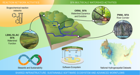
IDEAS-Watersheds Project. Each Science Focus Area’s multiscale scope includes enhancing biogeochemical reaction network models, stream and river corridor models, and multiscale models of hydro-biogeochemical function across the entire watershed. The shared infrastructure activities support required multiscale workflows and capabilities and deliver them through the software ecosystem.
IDEAS–Watersheds is organized around 3 partnership activities and 4 shared infrastructure activities to address important scientific challenges and advance software development methodologies and engagement in the growing community-driven software ecosystem.
Each partnership activity is undertaken jointly with interdisciplinary SFAs at Lawrence Berkeley National Laboratory (LBNL), Oak Ridge National Laboratory (ORNL), and Pacific Northwest National Laboratory (PNNL). These activities address hydro-biogeochemical function of watersheds across a wide range of scales and over disparate climate and land-use conditions.
LBNL/SLAC Watershed Function SFA: East River and Taylor River Watersheds. The Watershed Function SFA seeks to understand how mountainous watersheds retain and release water, carbon, and nutrients. The IDEAS–Watersheds partnership with the Watershed Function SFA aims to extend existing watershed-scale modeling capabilities to incorporate process models for multicomponent reactive transport and plant-microbe-soil interactions, including the associated feedback processes on water (e.g., evapotranspiration) carbon and nutrient fluxes. These capabilities include both the software tools and workflows required to enable this framework.
ORNL Watershed Dynamics and Evolution (WaDE) SFA: East Fork Poplar Creek and Reedy Creek Watersheds. The IDEAS–Watersheds partnership with ORNL’s WaDE SFA advances multiscale modeling approaches for understanding watershed hydro-biogeochemical dynamics under a range of hydrologic regimes, focusing on oxygen dynamics and metabolism in stream networks that drain heterogeneous land covers. The partnership is implementing multiscale models for stream metabolism and comparing those models to oxygen dynamics from sensor networks. The WaDE partnership is adding the capability to model burial, resuspension, and transport of sediment-associated solutes to the Advanced Terrestrial Simulator. This capability is of interest across ESS watershed-focused projects because significant transport of carbon, nutrients, and trace elements occurs as suspended sediment or sorbed to suspended sediment.
PNNL River Corridor SFA: Yakima River Basin. River corridor science is conducted in the context of larger watershed processes that define boundary fluxes and exert other controls on hydrological exchange. These controls include interactions among variable river surface elevation (“stage”), hydromorphic setting, and hydrogeological heterogeneity. To determine how these processes and interactions influence river corridor hydro-biogeochemical function, models must include land-surface and groundwater processes over domains much larger than the river corridor itself. The partnership activity with the PNNL SFA aims to enable fundamental understanding of the hydro-biogeochemical function of dynamic river corridor ecosystems and translate that understanding into predictive, interoperable models across watersheds.

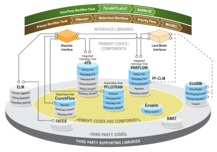
Software Ecosystem Improves Scientific Productivity. The IDEAS–Watersheds project enables scientific software development by building new applications from reusable, robust, and scalable software components and libraries, using the best available software development practices and tools. Software releases of primary codes and primary workflow tools are managed by software stewards and increasingly accessed through containers.
Shared infrastructure activities address the sustainability of the software ecosystem through the Software Stewards activity, developing nationally consistent data sets in the Integrated Hydrologic Simulation Infrastructure (IHSI) activity, addressing land surface model integration with Integrated Hydrology in the Land Model Interface (LMI) activity, and the Training activity.
Software Stewards Activity. Software stewards are responsible for coordinating software development, maintenance, testing, and deployment activities for primary simulation codes and workflow tools. This activity is critical to the software ecosystem’s sustainability and its effective use by the broader watershed modeling community.
Integrated Hydrologic Simulation Infrastructure Activity. To accelerate development and evaluation of watershed and regional models, IHSI addresses the need for consistent datasets and tools that can be used across watersheds to model water, energy fluxes, and transport. These include spatially consistent and expanded subsurface hydrogeology and groundwater datasets, as well as data subsetting and evaluation tools.
Land Model Interfaces Activity. LMI addresses the critical need for best practices in model setup and analysis of integrated hydro-terrestrial models, which combine coupled surface and subsurface flow with those vegetative and ecosystem processes found in land surface models.
Training Activity. The cohort of early career scientists jointly funded by IDEAS–Watersheds and the SFA partnerships, as well as early career scientists involved in IHSI and LMI, participate in software development best practices and modeling case study seminars, as well as short courses for various simulation codes and workflow tools.
Scientific and Community Impact
The IDEAS–Watersheds project has made significant progress in developing a flexible scientific software ecosystem to accelerate scientific discovery and understanding in environmental systems, including completion of open-source licensing and open access to source code repositories. In addition, code teams are adopting agile methodologies and developer workflows, improving sustainability while enhancing capabilities.

